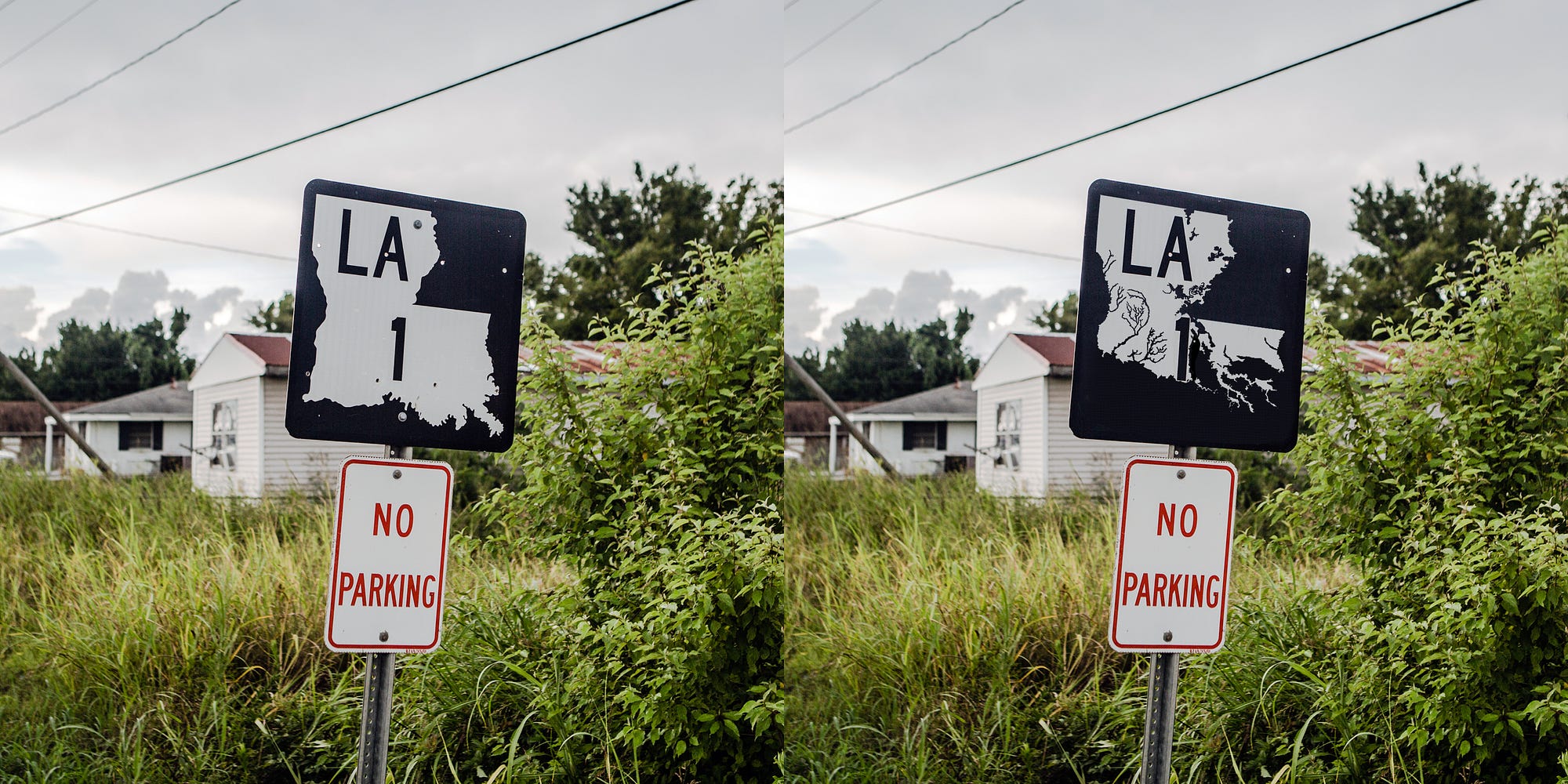
Louisiana Loses Its Boot
Geege Schuman stashed this in Climate
Stashed in: America!, Maps!, Weather!, Maps, New Orleans, uh oh, Climate Change!
Digital maps have expanded our freedoms to roam, removing much of the fear and hassle inherent in exploring unfamiliar terrain by exponentially decreasing the chances we will become hopelessly lost. But smart phone screens are programmed to spit out the granular information we need to get from point A to B. We don’t look to them to give us the large-scale views of border, land, and water of accurate paper maps. And so it’s becoming harder and harder to communicate the most urgent crisis facing Louisiana.
According to the U.S.G.S., the state lost just under 1,900 square miles of land between 1932 and 2000. This is the rough equivalent of the entire state of Delaware dropping into the Gulf of Mexico, and the disappearing act has no closing date. If nothing is done to stop the hemorrhaging, the state predicts as much as another 1,750 square miles of land — an area larger than Rhode Island — will convert to water by 2064. An area approximately the size of a football field continues to slip away every hour. “We’re sinking faster than any coast on the planet,” explains Bob Marshall, a Pulitzer-winning journalist in New Orleans. Marshall authored the series “Losing Ground,” a recent collaboration between The Lens, a non-profit newsroom, and ProPublica, about the Louisiana coast’s epic demise.
While the kind of state map that might have been useful for navigation or perspective was elusive on the road to Morgan City, the image such maps project — the iconic “boot” shape everyone recognizes as Louisiana — was impossible to escape. The map’s outline was ubiquitous on my drive: on bumper stickers (with the boot standing in for the “L” in “Love”), engulfing T-shirt fronts (my favorite emblazoned with “I drove the Chevy to the levee but the levee was gone”), and glowing on Louisiana-shaped neon beer signs in barroom windows.
But the boot is at best an inaccurate approximation of Louisiana’s true shape and, at worst, an irresponsible lie. It has to be.
Thanks a haunting image, that Louisiana loses a football field every hour.
"If nothing is done to stop the hemorrhaging, the state predicts as much as another 1,750 square miles of land — an area larger than Rhode Island — will convert to water by 2064."
It seems a futile endeavor to try to stop the Gulf of Mexico from going where it wants.
The Gulf wants Louisiana for itself!

In the face of so much shocking and widely available imagery, why does the boot look same as it did in the 1930s? That was why Jeff and I started devising an expose—this expose—about the boot. In our imagining, the idea spread beyond the confines of journalism, sparking a movement united around the cause of revising the boot in the spirit of advocacy and accuracy.
Supporters would mobilize armed with t-shirts, stickers, and posters, all printed with the image of an alternative boot. More wine brought talk of a website and a conference launched under some incendiary title. (The Map is a Lie! Change the Map Now!)
Politicians across the ideological spectrum would find common ground on the issue, because one thing environmentalists and global warming deniers can agree on is the basic fact that Louisiana is shrinking. The rest of the country would take notice, forging national agreement on the Master Plan and its funding as the most effective means for averting economic catastrophe. And then Jeff and I wouldn’t have to worry about tripping over more corpses, or being forced to move someplace with inferior cuisine.
Wow, I didn't realize how political it is. They really have their identity tied up in being a boot!
Louisiana is drowing, right now, and no one is noticing!
sounds like we need to get those recipes for boudin and cracklins....
Étouffée!!
So Louisiana is more likely to be submerged than Florida?
http://pandawhale.com/post/52383/the-folks-at-mit-say-florida-will-be-underwater-in-35-years


7:49 PM Sep 09 2014